Area 3 - 119 Sites
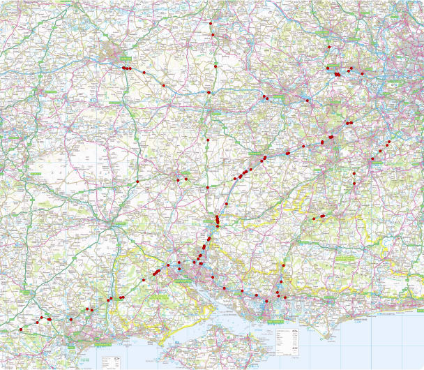
National Highways Area 3 includes Hampshire, Berkshire, Surrey, Oxfordshire, Dorset & Wiltshire
National Highways Area 3 - 119 Sites
Area 3 is National Highway’s second largest network carrying around 10% of the country’s overall traffic flows. It includes the M27, M3, M4, A3, A303 and the Hindhead Tunnel. Area 3 also provides the main link routes between several major towns and cities including Oxford, London, Reading and Swindon in the north and Bournemouth, Southampton and Portsmouth in the south.
The large scale project required detailed topographical suveys of the carriageway and verges, each survey measuring 600m long for the design and future replacement and installation of road signage for clearer visibility across the gradients on the road.

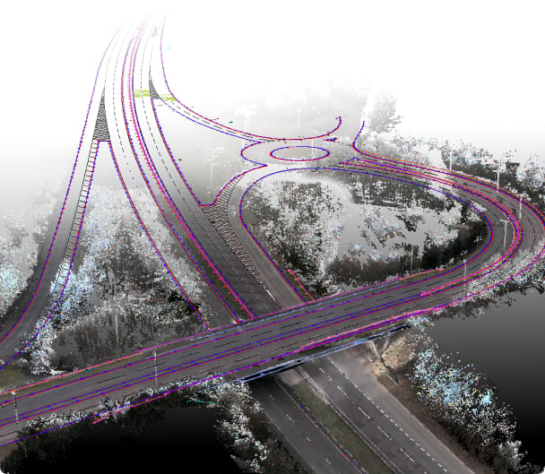
The topographical survey features for the design included the surveying of the carriageway extents, road markings, crash barriers, channels, top of kerbs, gullies, kerb weirs, verge levels, ironwork frames, sign locations, traffic loops, overhead cables, electrical boxes, railings, fences, steps, bridge soffit level and pier positions.
To survey these sites traditionally is a long and protracted operation using laser scanners, total stations and GPS, to collect thousands of points of data per day. Typically this would take a surveyor around 2 days per site to complete in the field. Also to survey this many sites would have required 119 individual traffic management installations. With a project of this size, there is a significant health and safety risk associated to all involved, to personnel being both in the carriageway and in the verge during all times of the day and night. A safer and more cost effective method was needed to deliver the project on time and in budget.
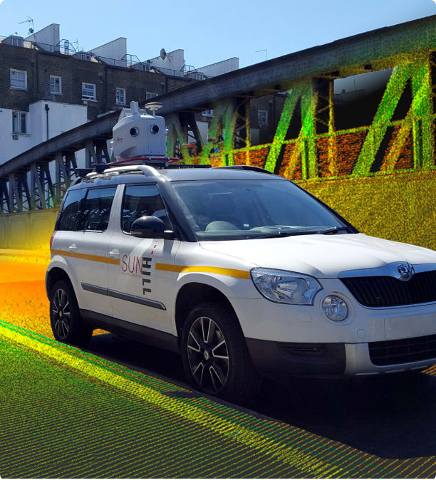
Leica Pegasu:Two and the mobile mapping process have revolutionised the world of surveying. Using the mobile mapping process and Leica Geosystems’ technology provided huge benefits to the Area 3 Highways England project. Access to all sites was left clear with no road closures required as the Leica Pegasus:Two acts in the same way as any other public vehicle when collecting the 3D geospatial data.
In total, the surveyors travelled more than 6,000km using the Leica Pegasus:Two to collect millions of points. There was no disruption to the network as traffic management was not required, allowing traffic flow to continue as normal. Safety to survey personnel was considerably improved using mobile mapping as no surveyors or traffic management crews were needed in the road as all data was captured from the safety of the vehicle. The virtual surveyors were able to create traditional topographical surveys from point clouds.
Mobile mapping provided a rapid data capture solution for Kier, saving them time, reducing safety risk and maximising value by reducing a 200 plus field day project to only 12 days with no traffic management. Furthermore, all 119 sites were surveyed and delivered a week before the final deadline, thanks to the speed of accuracy delivered through using the Leica Pegasus:Two. Sun Hill was able to deliver this project with less than 20mm absolute accuracy. The surveys were then delivered in a staggered program, allowing sites to be prioritised.
“At Kier we aim to be at the forefront of technology. The Leica Pegasus:Two is one of the most accurate mobile mapping units on the market and has helped deliver significant cost savings and all 119 surveys were delivered before the final deadline”
Chris Fuller - Roads Value Stream Manager, Kier Highways
National Highways Area 3 - 119 Sites
Related Services
Go to our Services Pages for the full range
Laser Scanning
Laser Scanning is a highly accurate non contact digital technology that captures the 3D geometry of a physical object using LIDAR
Read more
Mobile Mapping - Boat
A mobile mapping system is a vehicle mounted laser scanner which captures survey grade measurements over large distances while travelling at high speed
Read more
GIS Data Capture
As well as collecting the precise location of assets, Sun Hill can capture information about the asset
Read moreAccreditation and certification


