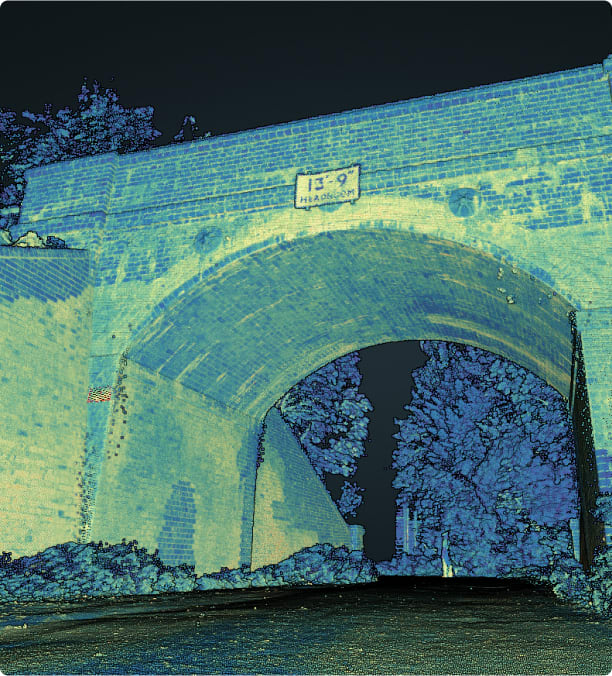
Height Clearance
Height Clearance and Sag Curve analysis helps to prevent bridge strikes and damage to critical highways infrastructure.
Professional Services
Sun Hill uses both mobile mapping and terrestrial laser scanners to collect high density LIDAR point clouds which are then assessed for height clearances and sag curve analysis.
Experienced Surveyors
Our surveyors have completed large scale projects of hundreds of structures and are experienced in both collecting height clearance data and performing sag curve calculations.
High Speed Data Collection
Through the use of mobile mapping and laser scanning Sun Hill can increase the speed of data capture and reduce the amount of time required on site. These surveying methods capture huge amounts of point cloud data which are used for high precision sag curve calculations.
Reduced Risk
Mobile mapping reduces the risk to our surveyors as data is captured remotely from the safety of our vehicle. Risk is further reduced as traffic management and traffic disruption is avoided through the use of mobile mapping. The speed of terrestrial laser scanning also minimises the amount of time surveyors have to spend on site.
Multiple Output Options
Sun Hill can deliver height clearance and sag curve analysis in a composit drawing displaying all aspects of the survey or as individual elements to suit your requirements.
Our outputs are specifically tailored to your needs and can include shapefiles, spreadsheets and online GIS viewers - Learn more
Case Study
Sag Curve Analysis | Hertfordshire
Sun Hill was tasked to undertake sag curve surveys of 182 structures across Hertfordshire using the Leica Pegasus:Two mobile mapping unit and terrestrial laser scanners in inaccessible locations.
This required extensive planning in order to survey all 182 structures in the most efficient way possible. The aim of the surveys was to perform sag curve analysis, produce reports, topographical surveys and deliver online web services for each structure.
This methodology saved the client time, money and delivered not only a full sag curve report on each structure, but also allowed the client to view and analyse the structure’s point clouds using Sun Hill’s web services.

Related Services
Go to our Services Pages for the full range
Laser Scanning
Laser Scanning is a highly accurate non contact digital technology that captures the 3D geometry of a physical object using LIDAR
Read more
Mobile Mapping - Car
A mobile mapping system is a vehicle mounted laser scanner which captures survey grade measurements over large distances while travelling at high speed
Read more
Topographical Surveys
A topographical survey is a highly accurate 3D drawing identifying both natural and artificial features within an area of interest
Read moreFind out more about Height Clearance
Accreditation and certification


