Photogrammetry Modelling
Photogrammetry uses multiple photographs captured at a variety of angles to create a 3D model using the parallax of the images.
Professional Services
Sun Hill is experienced, qualified and certified to fly drones in a wide range of environments
Civil Aviation Authority Accedited
Sun Hill’s experienced and qualified drone pilots maintain all the required insurances, Civil Aviation Authority permissions, RAMS and CSCS cards.
High Speed Data Collection
Photogrammetry models are made using hundreds or even thousands of high resolution images which are captured by a drone. By using a drone surveys can be completed quickly and without the requirement of expensive and time consuming scaffolding or manual access. Measurements and visual inspections can then be carried out by analysing the photogrammetry model.
Reduced Risk
The ability to survey from a drone platform increases safety and reduces risk by eliminating the requirement for workers to operate at height in order to assess condition or measure works.
Multiple Output Options
Our outputs are specifically tailored to your needs and can range from traditional 3D CAD drawings to 3D point clouds and photographs.
Sun Hill also provides online Web Services which enable point clouds to be viewed and analysed remotely through a web browser - Learn more
Case Study
Proposed Rail Bridge | Bedfordshire
Sun Hill was tasked with generating a model of a railway cutting using drones.
This required utilising our team of drone and surveying professionals to take a large number of drone images near to a live railway with a dangerously overgrown and steep embankment.
Working within the CAA and Network Rail legislation and requirements we were able to quickly establish the images required for an accurate point cloud model and topographic drawing.
No rail possessions or hazardous operations on a rail embankment were required, avoiding considerable costs and hazardous work.

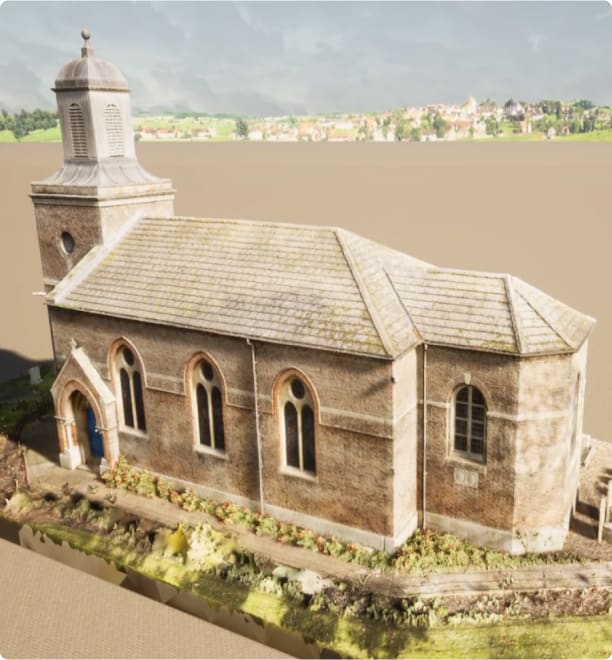
Photogrammetry Modelling – Quadring Church
Drone surveys capture all the required data without the requirement of expensive and time consuming scaffolding or manual access
Related Services
Go to our Services Pages for the full range
Drone Inspections
State-of-the-art drone technology uses photogrammetry to produce highly accurate 3D models
Read more
Progress Surveys
With regular visits to sites our drones can provide updates on change and progress using a variety of outputs
Read more
Traffic Monitoring
Our drone technology can monitor the flow of traffic around key junctions from an aerial perspective
Read moreFind out more about Photogrammetry Modelling
Accreditation and certification


