Mobile Mapping - Car
A mobile mapping system is a vehicle mounted laser scanner which captures survey grade measurements over large distances while travelling at high speed
Professional Services
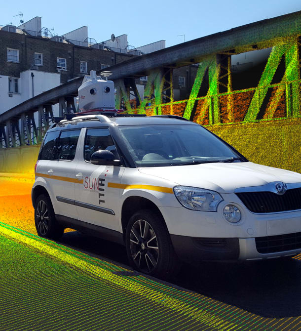
Sun Hill uses the industry leading Leica Pegasus:Two to record survey grade 3D point clouds with calibrated 360° imagery from a car, boat or train
Industry Leaders
Sun Hill is one of the leading mobile mapping companies in the UK. Being an early adopter of mobile mapping technology has allowed Sun Hill to develop expertise in all aspects of mobile mapping.
Traffic Management Not Required
Our Leica Pegasus:Two mobile mapping system collects 1,000,000 measurements per second while travelling at road speed. As a result there is no need for traffic management to be deployed, saving our clients both time and money.
Reduced Risk
The risk to our surveyors, traffic management crews and the wider public is reduced by the use of mobile mapping as all the work is carried out from the safety of our vehicle without any disruption to traffic flow.
Multiple Output Options
Our outputs are specifically tailored to your needs and can range from traditional 3D CAD drawings to 3D point clouds and photographs. In addition to these outputs our mobile mapping system can be customised to collect road condition, bridge soffit or thermal images.
Sun Hill also provides online Web Services which enable point clouds to be viewed and analysed remotely through a web browser - Learn more
Case Study
National Highways Area 3 - 119 Sites
Sun Hill was tasked to undertake a mobile mapping survey of 119 sites across southern england using the Leica Pegasus:Two mobile mapping system. This complex project required extensive planning in order to scan all 119 sites in the most efficient way possible.
The aim of the project was to survey the existing sign infrastructure and the area around the signage in order to produce 3D topographical surveys of each site
Using mobile mapping Sun Hill was able to complete the project without any use of traffic management. This in turn saved time and money for the client, while reducing risk for our surveyors as all surveying was undertaken from the safety of our vehicle.

Mobile Mapping – Leica Pegasus:Two
Related Services
Go to our Services Pages for the full range
GIS Data Capture
As well as collecting the precise location of assets, Sun Hill can capture information about the asset
Read more
Laser Scanning
Laser Scanning is a highly accurate non contact digital technology that captures the 3D geometry of a physical object using LIDAR
Read more
Mobile Mapping - Boat
A mobile mapping system is a vehicle mounted laser scanner which captures survey grade measurements over large distances while travelling at high speed
Read moreFind out more about Mobile Mapping - Car
Accreditation and certification


